| 1978 |
|
On September 25, a Pacific Southwest Airlines Boeing 727
collides with a Cessna 172 in the skies over San Diego, California.
All 135 passengers on board the 727 and the two pilots in
the Cessna were killed. Seven people on the ground were
killed by the falling debris, and an additional nine
persons were injured.
Both aircraft received voice notification of the approximate
location of each other, however the National Transportation
Safety Board determined that the probable cause of the crash
was the failure of the 727 to maintain visual separation with
other air traffic.
One of those killed in the crash is a friend of Dr. Gerard ("Jerry") O'Neill.
|
| |
| 1980 |
|
 Work begins on a method of geolocation using two or more satellites.
In September, Dr. O'Neill files a patent for a "Satellite-Based
Vehicle Position Determining System."
Called Triad, it is based on the use of three satellites to
provide coverage to North America.
It is eventually granted U.S. Patent 4,359,733 in 1982.
|
| |
| 1981 |
|
In June, the Federal Communications Commission (FCC) adopted a
Notice of Inquiry (NOI) (46 Fed. Reg. 51259; 87 FCC 2d 876), for the
authorization of certain types of wideband modulation systems, including
spread spectrum. The FCC defines it this way:
Spread spectrum is a term applied to communications systems that spread
radio frequency energy over a wide bandwidth by means of an auxiliary spreading
code. The spreading of the bandwidth can be accomplished in many different ways
and the systems are usually classified by the type of spreading technique which
they employ. They are commonly referred to as: direct sequence (or
pseudonoise), frequency hopping, time hopping, pulsed FM (or chirp) and hybrid
systems.
The spreading or dilution of the energy in spread spectrum systems
over a wide bandwidth results in several possible advantages: short range
interference-free overlays on other emissions, resistance to interference from
other emissions, and low detectability. While we do not anticipate that spread
spectrum will replace other types of modulations, the unique characteristics of
spread spectrum offer important options for the communications system designer.
|
| |
| 1983 |
|
Geostar Corporation is formed in March, based in Princeton, New Jersey.
Application is made to the FCC in April for a license to construct
the Global Satellite System (GSS). The system called for
three geosynchronous satellites,
located at 70° W, 100° W, and 130° to cover the continental United
States and adjoining waters.
The application indicated GSS would be able to locate an individual
$200 transceiver as well as carry short (36-character) messages.
Dr. O'Neill is interviewed
for OMNI magazine.
The following What's News appeared in the September issue of
Radio-Electronics magazine:
Satellite services for individuals?
Geostar Corp of Princeton, NJ, proposes a satellite-communications system that
would permit persons to send messages via satellite, using devices no bigger than
pocket pagers. The system will locate the exact position of the sender, and
handle messages of up to 36 characters.
In its application to the FCC, Geostar states that a person confronted by a mugger
could press a single button on his communicator. That would send out a signal that
would go to three satellites in geostationary orbit over the Equator, and from them
back to a computer on Earth. The computer would determine instantly the exact
location of the sender by noting the difference in the time it takes for signals to
reach the computer from the different satellites. It would then notify the nearest
police car or station.
The system would also be valuable to hunters and others lost in the woods, and
would be of great value to trucking companies, who would make large savings if
they could determine the location of - and communicate with - their trucks at all
times.
The proposal has not found favor in all quarters. The cellular radio services - some
of whose alloted frequencies Geostar proposes to use - are particularly unhappy.
AT&T and Motorola Inc., both of whom are heavily involved in cellular radio,
have opposed plans of Geostar's type, stating that such systems would waste
frequencies in serving remote areas; such frequencies could be used better in urban areas.
An article appeared in the September issue of Data Communications
magazine:
CELLING A SATELLITE DATA NETWORK
SOUTH LAKE TAHOE, NEV. - A new satellite-based digital network,
scheduled to be operational by 1988, will permit anyone in North
America with a $500 hand-held transceiver to send and receive
textual messages and data to and from any other location - without
requiring ground-based connection facilities or large external antennas.
The relatively low-speed scheme is a sort of data version of existing
analog cellular radio technology, but on a nationwide scale.
The project is the work of Dr. Gerard O'Neill, a longtime Princeton
University physics professor who now heads Geostar Corporation in
Princeton, N.J. O'Neill was granted an extensive patent by the U.S.
Patent Office last year that, his colleagues say, covers 49 new
technological claims. Many of these, relat ing to satellite
communications, will reportedly make the scheme possible.
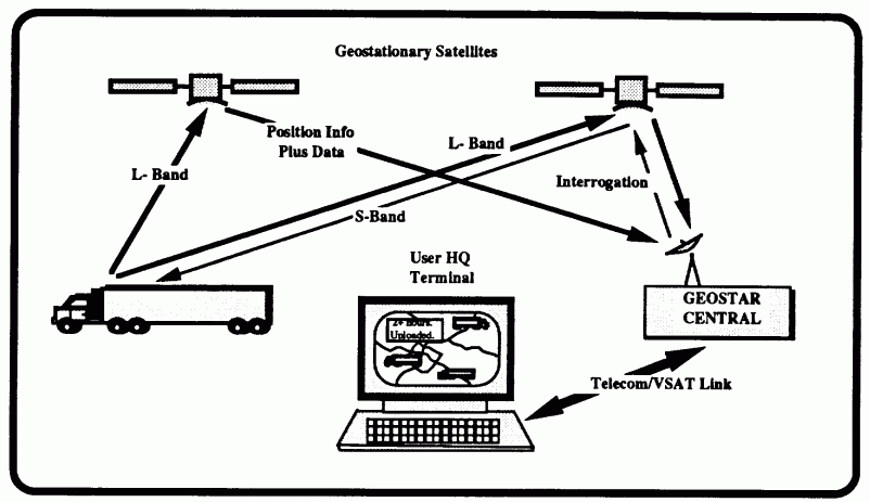
Airline locator. The Geostar project was undertaken to provide
a new, reliable, and highly accurate
means of determining the exact positions and altitudes of commercial
airplanes. Their locations will be tracked and compiled by a large
central computer, which will facilitate air traffic control and,
presumably, all but eliminate the threat of mid-air collisions.
The plan calls for three satellites to be put in geostationary orbit and
for a transceiver (transmitter/receiver) to be placed aboard the
aircraft. The transceiver constantly
listens for "interrogation" messages, sent via satellite from the
central computer, and responds on a regular basis with a message that
includes a unique identification character sequence.
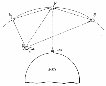
The three satellites each receive the response and relay it to the
ground-based computer, which, based on the propagation delays of
the responses, triangulates the
plane's longitude, latitude, and altitude. The calculated location,
Geostar claims, will be accurate to within 50 feet.
Realizing that the scheme would also support locating mobile,
ground-based targets - as well as
two-way digital data communications from anywhere - Geostar
went back to the drawing board and enlarged the scope of the plan.
O'Neill says that plans are already
under way by fleet owners and traffic managers to use the service to
keep track of trucks and other ground vehicles.
Battery-powered. Geostar conducted a test here recently of its
data transmission capability, using
leased satellite transponder capacity from another carrier. Geostar
does not expect its own three satellites to be launched until 1987. Field
trials have reportedly established that the scheme works.
A portable data-entry terminal, transmitter, and power pack were
employed in the tests. However, Geostar expects that by 1987 an
integrated unit containing all of the components, including a miniscule
two-inch dipole antenna for both receiving and transmitting, will be
no larger than a carton of cigarettes. This unit, says Geostar, will
be powered by a wristwatch battery. A great deal of power is not
required to transmit to, or receive from, a satellite, but the Geostar
plan represents a unique miniaturization of both antennas and power
supplies. According to Geostar's
Les Snively, the low-power requirement is sufficient for the way the
transceivers operate.
The "duty cycle" of the transceiver - the time that the
transmitter is actually working - is only 20
microseconds. In that period, the unit sends a 256-bit block of some
36 characters to the satellite. This is
done in response to a received interrogation signal, broadcast to
every location 100 times each second. How often the transceiver is
programmed to send these digital blocks (from several times a second
to perhaps only once every few
minutes) determines both the effective data rate for the user and the
amount of power required by the transceiver.
Even with a wristwatch battery, which Geostar acknowledges may
be inadequate for extensive data transmissions or a sustained data
rate of more than about a few hundred bits per second, a peak pulse
power of 375 watts is achieved for the very short transmission burst.
When not transmitting, the average amount of power used, says
Snively, is "in the microwatt region." With a slightly stronger
power supply, using a module that can readily be employed at home,
in a car, or on a ship, a 300 bit/s data rate would be no problem,
says Snively.
Half-duplex. Another breakthrough in the Geostar scheme is
the small dipole antenna. The handheld unit will reportedly contain an
antenna only two inches in length that will receive messages from the
satellite, then transmit the data
bursts. The antenna size is consistent with the network frequencies;
the entire three-satellite network uses the same up-link frequency, a
16.5 MHz-wide band centered at 1.618 GHz, and the same down-link
frequency, centered at 2.492 GHz.
The network operates digitally. Each up- and down-link supports
an aggregate 12.5 Mbit/s, which is dynamically allocated to users in
transmit time slots of 20 microseconds in duration.
The control technique is basically time-division
multiple-access (TDMA), which is a well-defined and long-employed
method of handling access to a single satellite digital channel by a
multitude of users. Geostar says that with this technique and the
planned capacity, the three-satellite network will be able to support 100
million users.
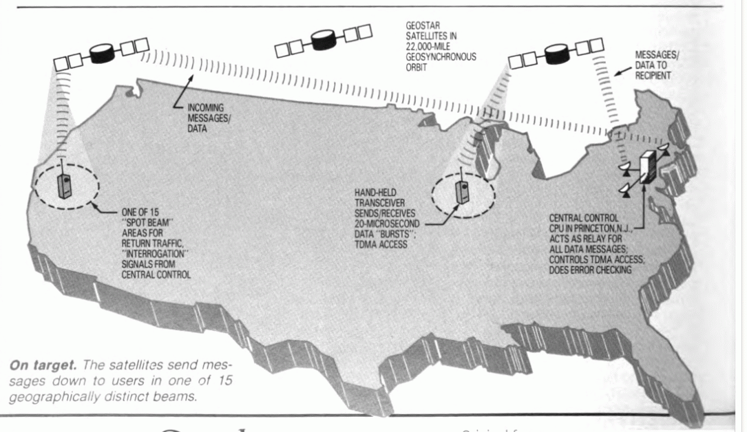
To further increase the capacity of the network, "spot beams" will
be employed, which make the setup similar to a giant cellular radio
arrangement. The satellites send messages down to users in one of
15 geographically distinct beams,
each of which covers an oval-shaped area of land of about 300
by 500 miles. These beams overlap a little, but they permit the satellite
to use only valuable down-link transponder bandwidth in the
spot beam area where the user is located.
Each spot beam transmits some 15,000 messages per second, for a
total network down-link capacity of
over 200,000 messages per second. The spot beams also permit
transmission power to be focused, which is another reason why the
tiny transceiver antennas will be able to receive transmissions that in
other satellite networks without spot beams require dish antennas
at least three feet in diameter.
Users will be able to enter a considerable amount of text or data
into the transceiver's buffer memory, but transmission will not begin
until the operator first identifies the destination station, then hits the
transmit key. Since a single buffer will be employed, users will first
have to send their entire message before they can receive a message.
Even so, logic in the transceiver works with the central computer to
perform error-checking and acknowledge each burst of data.
Forward error-checking is applied, but
retransmission is invoked when errors are detected via a block-check
algorithm.
Studying uses. Geostar says
that priority for network data traffic
will be given to the aviation industry. Even so, user text and message
transmission is expected to represent the bulk of the service. An
insider says the entire air traffic control application is expected to
use only 2 percent of the network's capacity.
According to O'Neill, the capacity to transmit data over the same
transceiver used in planes or trucks for positioning will still be there. He
adds that airplane flight crews taxiing on runways might use the
network, say, to send passenger or maintenance data to a central or
regional computer site.
Geostar is said to have spent almost $2 million developing the
scheme. O'Neill says that $200 million will ultimately be needed to
build and launch the three satellites
needed to make the network operational. He says he expects other
manufacturers to mass-produce the message transceivers (including
wall-size map displays for tracking
and positioning), adding that operational and interface specifications
will be made available for this purpose, probably on a license basis.
O'Neill and Geostar would naturally like the network to become the
basis for a nationwide, ubiquitous,
and inexpensive electronic mail service, and the firm is predicting
prices that will likely be attractive to
microcomputer users over, say, a
phone line. The transceivers are expected to cost about $450 each,
and the service is expected to be priced around $10 to $30 per
month. O'Neill says that for data communications applications, this
monthly service charge will likely be based on the volume of characters
carried over the network.
Geostar acknowledges that data rates will be limited, due to the
network's basic design, making the
service attractive for short and interactive applications - especially
from remote or mobile sites. But it
will hardly be feasible for high-speed or bulk-data transmission.
While the prices seem to be attractive, the biggest sales point will
likely be the complete independence of the transmission scheme
from the telephone company and
associated connection and long-distance costs. Because the system
will be satellite-based, transmitting across the country via Geostar
should be no more expensive than
transmitting across town. - Edwin E. Mier
In November Geostar demonstrates a prototype system in the Sierra mountains
of California using mountaintop pseudolite repeaters.
An article appeared in the December issue of Data Communications
magazine with the following abstract:
A new satellite data network using low speed analog cellular
technology will allow users with hand-held transceivers to send and receive
text or data from any location without ground-based connections. Aimed at
tracking commercial airlines, this network will also be used in business for
tracking a local auto or truck fleet. Message transceivers will cost $450. The
monthly service charge will be $10 - $30 per month. The project has been
developed by Dr. Gerard O'Neill, former physics professor at Princeton who now
heads the Geostar Corp. Nearly $2 million have been spent in development; $200
million will be needed for the satellites.
|
| |
| 1984 |
|
The FCC decides to allocate frequencies to an operational
satellite system for radio determination services. These decisions
are issued in rulemaking Dockets 84-689 and 84-690 and codified in
47 CFR Section 25.392.
In a Conressional appropriations hearing with the Federal Communications
Commission (FCC), the following exchange occurred between Mark Fowler,
the Chairman of the FCC, and John Porter, a Congressman from Illinois:
Mr. Fowler. If I might, I was talking to the Chairman
about a new area that
absolutely fascinated me. I served a presentation the other day on
a new technology called Geostar. It essentially involves putting
three satellites up. You have a small unit which has a very small
transceiver inside of it, and it costs, I think, about $100 ultimately.
With this system you are able to send messages and receive
messages to any person who subscribes to this. They can serve about 50
million people with this system in the United States, but because
the signal goes up and is capable of being triangulated by the
different locations of the three satellites, your location can be
determined within three meters anywhere in the United States. So if
you are lost in the forest, they will be able to locate you within
three meters.
People who have fleets of trucks will be able to know exactly
where their trucks are. The aviation industry is looking at this, be-
cause if one of these is put in each plane, and by using a computer
system and programs, the computer would be able to instanta-
neously alert any plane, small or large, that was on a collision
course with another airplane well in advance. This could, once and
for all, eliminate the possibility of collisions.
It is an amazing system. I haven't looked at it to see whether it
is as technically sound as they say it is, but apparently it has
received a lot of good reviews. We will be looking at that. That is an
example of something I wanted to mention this morning.
The only reason I do that is because this Committee, more than
most, is always interested in some of the new stuff coming down
the road, and I thought I would mention it to you.
Mr. Porter. You are probably in one of the most fascinating
areas of the economy and of the government that exists, so we are
always interested in these new ideas.
Thank you, Mr. Fowler.
Mr. Fowler. Thank you, Mr. Porter.
In an interview with COMPUTE! magazine, the Geostar system is described as:
Despite his many other interests, it is the Geostar Corporation which currently occupies most of O'Neill's time and effort. Geostar, a development firm concerned with communication and navigation via satellite, is a perfect blend of O'Neill's farsighted vision and his make-it-work practicality.
The system which O'Neill and his colleagues are developing could revolutionize how we track and monitor aircraft and how we communicate with one another. Initially, the proposed system would have three satellites in geosynchronous orbit over North America. The Geostar central computer facility would use the satellites to route tracking and communication data almost instantaneously for everything from commercial airlines to trucking companies, taxi services, police departments, and even individuals. The key to the system will be a hand-held transceiver which can send and receive messages through the Geostar network.
During the interview, he remarked that an airplane thousands of feet above Princeton was in the process, at that moment, of testing the Geostar system.
The interview also contained the following exchanges:
COMPUTE!: There are predictions that by 1988 some 50 million homes
in the U.S. will have personal computers. In what ways do you see this
increased awareness of computers affecting America's technological edge
in the world?
O'Neill: I think it will help a lot. It's already true, just
because of the accident that we work on an alphabet and the Japanese work,
of course, with a character-based system, that we as a people are far
more familiar with keyboards than they are. Young Americans growing up
nowadays, working with personal computers, are much more familiar with
keyboards, much less scared of them, than the older generation.
Geostar is a digital system, a keyboard-type system. It's not a voice
system. It could be connected to a personal computer anytime. The
message transfer capability is entirely consistent with the kind of
telecommunications that you like to carry out with your personal computer,
from a portable computer. And, of course, by 1987, today's three or four
pound computers that fit in a briefcase are probably going to be shrunk
down to a quarter of an inch thick. You can carry those along with a
Geostar transceiver, and be in instant touch with anywhere.
COMPUTE!: You have already completed mountaintop and airplane
emulations of the Geostar satellite functions. What's the timetable for
the actual satellite?
O'Neill: So far, the company has met all of its milestones. We are
looking to begin service to the entire continental United States in 1987.
One of the most critical items for that is the issuance by the
Federal Communications Commission of what's called a "notice of
proposed rule-making," which would allocate the spectra for the Geostar
service. And that is going very well. There's a very strong possibility
that something important will have happened in that area even before
your magazine comes out.
The development of the transceivers actually takes just about as long
as the development time for the satellites themselves. It's a different
kind of technical task, but the time scales are about the same.
COMPUTE!: What types of services will Geostar provide?
O'Neill: In aviation, the kinds of services that would be provided
would be, for example, positioning, very accurately.on the order of
meters. We can technically provide what's called radio location, which
means feeding back the location of a vehicle or an aircraft to a fleet
dispatch headquarters. We can provide for aircraft terrain avoidance,
because we will have the stored terrain map. So if we see an aircraft
heading toward a TV tower or a mountain, we will be feeding warnings to
the pilot at the time.
There would be, of course, a two-way digital message service, all provided
through the same device. And you could send a message from any transceiver
to any other transceiver with a typical delay of about six-tenths of
a second. And lastly, it is also an emergency warning system, because
the ground station computer will be tracking aircraft. And if you see an
aircraft which is heading toward a collision with terrain, first of all,
you'll be sending warnings, automatically generated by the computer,
and if the aircraft does crash, you will recognize the fact from several
confirming sources. And that's important, because the so-called emergency
locating transmitters (ELT) that are now federally mandated and carried
by aircraft have a horrendous false alarm rate.approximately 98 percent
of all ELT firings are false alarms.
COMPUTE!: How would Geostar have an impact on aviation?
O'Neill: The way that Geostar would affect aviation is sort of
generically the same way that it would affect a number of other situations
in life and affairs. The difference is that in aviation, all the needs
come together in one place. The fundamental thing is that the Geostar
transceiver is a very light, simple, inexpensive thing, which in effect
can run on double-A cells. It's a goal which the manufacturers regard
as not at all impossible.
|
| |
| 1985 |
|
RCA Astro contracts with Geostar in April to develop an L-band inbound
(mobile unit to central hub)
transponder.
In November, Geostar signs a Space System Development Agreement (SSDA)
with NASA for satellite launch services.
|
| |
| 1986 |
|
GSTAR-2 is launched on March 11 carrying a Geostar payload,
but suffers catastrophic failure during on-orbit testing
in late May.
In August the FCC officially completes the rule-making process
for the RDSS frequencies. They grant three licenses -- one to
Geostar, one to MCCA Radiodetermination Corporation, and one
to McCaw Space Technologies, Inc.
In a 1986 issue of Customs USA, published by the Information
Services Division of the U.S. Customs Service, the following report
was made:
SATRACK - Was initially conceived in 1982 to determine if satellite tracking
systems could be used in support of
various Customs enforcement activities. The satellite system should
provide position and tracking functions at a very minimum.
Three systems have since been identified
that could meet Customs operational requirements. They are the
Global Low Orbiting Message Relay
(GLOMR) satellite now being operationally
tested by the Defense Advanced Research Projects Agency
(DARPA). The second system is the
NAVSTAR Global Positioning System
(GPS), a multisatellite system being
established by the Department of
Defense as a very accurate position
location system for mobile units. The third system is the GEOSTAR system.
Electronic Identification Tag (EIT) System - Since 1982 Customs
has conducted experiments under project SATRACK to determine if satellite
tracking (position location) systems
could be used in support of Customs
law enforcement activities.
Customs requires a system which
provides continuous coverage extending from the U.S./Canada border to
northern South America, with tag
position data updated in real time.
ln 1986 Customs generated the performance specifications for the
development of a miniaturized Electronic ldentification Tag (ElT) system
which would operate with a geosynchronous satellite.
A number of potential contractors were selected to compete in the
contract bidding process.
From an Inmarsat News Release (NR86/32/2846B) dated November 27, 1986:
INMARSAT Grants Free Satellite Use For Geostar Experiments
Inmarsat will provide free capacity on one of its satellites to the
US Geostar Corporation for tests and demonstrations of a land mobile
position reporting and communication satellite service. The request
for experimental capacity was received by Inmarsat from its US Signatory
member organization, Comsat Corporation. The purpose of Geostar's proposed
experimental programme is "to test the use of satellite communications
for position reporting in the land mobile environment." The test and
demonstration will be carried out with 30 vehicle terminals sharing a single
L-band to C-band frequency channel in random access mode. The programme is
expected to start about the end of 1986.
"Inmarsat's in-principle agreement to this request is in line with its
long-standing policy of providing free access to its satellites for
experiments which promise the possibility of expanding and improving mobile
satellite communications technologies and applications," Inmarsat's
Director General, Olof Lundberg, said. "This is in fact the 24th
programme of this nature supported by Inmarsat." However, Mr. Lundberg
emphasized that, since 1979, Inmarsat and its forerunner Marisat had provided
services which had enabled both automatic position reporting via satellite
from ships and other mobiles, and the interrogation of mobile position
information from customer premises (polling). This service is now widely
used by mobiles equipped with Inmarsat Standard-A communications terminals.
"With the introduction in the next year or so of Inmarsat's new low-cost
miniature Standard-C communications terminals, we expect the use of the
Inmarsat system for this type of application to increase greatly," he
said. "Next year, we shall also conduct experiments, using our satellite
system, into position determination by ranging as well as another series of
trials in support of other navigation systems."
|
| |
| 1987 |
|
Field testing begins in January using two low-earth polar orbiting
NOAA ARGOS satellites. Position location is performed using Doppler;
no messaging is possible. (This was known internally as System 1.)
 Eight transportation companies trial more than 100 user terminals,
including Mayflower Transit.
Eight transportation companies trial more than 100 user terminals,
including Mayflower Transit.
Geostar moves their corporate headquarters and processing center
from Princeton, New Jersey to K Street in downtown Washington, D.C.
In the 53th Annual Report for Fiscal Year 1987,
the Federal Communications Commission summarizes Radiodetermination
Satellite Service activity thusly:
Following its 1985 allocation of frequencies for a
Radiodetermination Satellite Service (RDSS), the Commission
in 1986 authorized a system design that would permit
multiple RDSS systems to operate simultaneously on
the same frequencies to provide RDSS and ancillary non-
voice message service, and authorized the three proposals
before it that conformed to the adopted design. A fourth
applicant subsequently amended its nonconforming
proposal, and its application was granted in March 1987.
While two of the licensees have decided not to proceed
with their systems, one, Geostar Corporation, has begun
to provide start-up service by placing RDSS packages on
domestic fixed-satellites. RDSS packages were authorized
to be added to several GTE Spacenet satellites for Geostar
in 1987.
|
| |
| 1988 |
|
GE Americom Spacenet-3 is launched in March with an RDSS L-band receive-only
package.
Geostar begins commercial operation using
Spacenet-3,
with the capability of serving upwards of 40,000 users.
(This was known internally as System 2.)
Users transmit a direct-sequence spread spectrum burst at 1618.25 MHz.
The burst has an 8 MHz chip rate and a 15.6 kHz data rate.
User terminals transmit their position, derived from an on-board LORAN-C
receiver, to Geostar Central for delivery to the customer.
A return link at 2491.75 MHz is in the planning stages, but for now
the Geostar service is one-way only.
Geostar acquires an 11.5 percent stake in Locstar, a consortium made
up of European companies and government entities including British
Aerospace and Alcatel. The consortium plans to provide RDSS in Europe,
the Mideast and North Africa.
European patent EP 0174540 is granted to Geostar Corporation.
In November,
San Diego-based Qualcomm, Inc. begins offering their two-way OmniTRACS
mobile communications service via Ku-band satellite (two transponders on-board
GSTAR-1). Qualcomm
had purchased a smaller company called Omninet that had developed
the system. The FCC granted Qualcomm an STA (Special Temporary
Authority) in September for 2,000 terminals.
A space industry survey conducted by the U.S. Department of Commerce forecast
worldwide annual revenues from RDSS systems were expected to reach $150
million to $200 million by 1992, and total $1 billion or more in 1995. Part
of the increase in revenues is attributed to production economies of scale
for RDSS terminals, with user equipment declining in price from about $4000
to less than $500. These estimates were obtained from suppliers and were not
independent government forecasts.
The Geostar forecast indicates costs declining from $3,000 for first generation
terminals to less than $500 in mass production.
In the 54th Annual Report for Fiscal Year 1988,
the Federal Communications Commission summarizes Radiodetermination
Satellite Service activity thusly:
Following its 1985 allocation of frequencies for a
Radiodetermination Satellite Service (RDSS), the
Commission in 1986 authorized a system design that
would permit multiple RDSS systems to operate
simultaneously on the same frequencies to provide
RDSS and ancillary non-voice message service, and
authorized the three proposals before it that conformed
to the adopted design. A fourth applicant
subsequently amended its nonconforming proposal,
and its application was granted in March 1987. While
two of the licensees have decided not to proceed with
their systems, one, Geostar Corporation, has begun
to provide start-up service by placing RDSS packages
on domestic fixed-satellites. RDSS packages were
authorized to be added to several GTE Spacenet
satellites for Geostar in 1987 and 1988. Although it
has experienced some technical difficulties, Geostar is
currently providing start-up RDSS service to customers
using the Spacenet III satellite launched in March 1988.
|
| |
| 1989 |
|
A typical installation costs about $3,300 for transceiver, antenna
and keyboard. The Geostar link runs $45 a month for one transmission per
hour, 24 hours per day, and a nickel for each additional transmission.
In October Geostar begins offering two-way service by
transmitting an "outbound"
signal (from the central hub out to mobile terminals)
between 3700 and 4200 MHz (C-band).
(This was known internally as System 2C.)
Although the C-band frequencies
were originally allocated for Fixed Satellite Service (FSS), the
FCC allowed mobile operation in the band due to a lack of S-band satellite
capacity in the allocated RDSS band (2483.5 to 2500 MHz).
 Equipment is built by Hughes Network Systems (L-band transmitter),
Kenwood Corporation (C-band receiver)
and Sony Corporation (L-band transmitter).
Equipment is built by Hughes Network Systems (L-band transmitter),
Kenwood Corporation (C-band receiver)
and Sony Corporation (L-band transmitter).
A contemporaneous description of the planned Geostar positioning service
is described thusly:
In the RDSS system, a continuous outbound signal is transmitted to provide
time reference marks and an outbound time division multiplex data stream.
To determine the position of a mobile unit, the mobile unit retransmits one
of the time reference marks, adding its unique identification code, through
two or more geosynchronous RDSS satellites. The position of the mobile unit
is calculated at the central earth station from the round trip propagation
times through three satellites, or by the round trip propagation times
through two satellites and altitude information obtained from a digitized
terrain map or on-board altimeter. The relative positioning accuracy of the
RDSS system is less than ten meters and the absolute ranging accuracy is
under fifty meters.
In the 55th Annual Report for Fiscal Year 1989,
the Federal Communications Commission summarizes Radiodetermination
Satellite Service activity thusly:
In FY 1989, Geostar Positioning Corporation
continued to implement its plans to construct and
launch a radiodetermination satellite service
(RDSS) system. In addition to continuing construction
on its three dedicated RDSS satellites, Geostar
has been authorized to provide interim service
using capacity on domestic fixed-satellites. In 1989,
the Commission authorized Geostar to use domestic fixed-satellite
C-band frequencies for the interim
system's downlink transmission from GTE
Spacenet fixed-satellites to the mobile user units.
This link permitted Geostar to provide two-way
communications capability on its interim system.
|
| |
| |
|
|
| |
| 1990 |
|
In February, Geostar demonstrates RDSS technology to remotely determine
the position of a mobile platform. The demonstration shows the ability
to determine position to an accuracy of better than 50 meters, using
just two geostationary satellites and a digital terrain map.
At a Congressional hearing in Marcha entitled
High-technology weapons in the war on drugs, the following
exchange took place:
Q: At the hearing, you testified that the Customs Service is part
of a consortium of military and civilian agencies developing
"an innovative satellite based covert tracking system with many
law enforcement and defense applications." Please describe the
project.
A: The project to develop the satellite based tag is called the
Electroic Identification Tag (EIT) system. At present, Customs is
under contract to develop the tag. Geostar, the prime contractor,
manages the project, and Motorola, the subcontractor, is developing
the commandable device. The contract was awarded in September 1986;
70 prototype tags are scheduled for delivery in October 1991.
Q: Has consortium selected a system and what is the time frame for
deploying it?
A: Customs and consortium members have selected Geostar's System 3.0
which was scheduled for deployment in November 1991. However, because
of fiscal problems, Geostar recently announced that the satellite launch
for System 3.0 has been rescheduled for calendar year 1993 time frame.
We are exploring means to minimize the impact of this delay.
Q: Is this expected to operate off an existing satellite or do you
plan to deploy one?
A: The EIT device is designed to operate with a future commercial
satellite to support System 3.0. The System 3.0 satellite launch
schedule is given above. Customs and consortium members have no plans
to launch, nor deploy another satellite to support the EIT device.
Q: Are there other, similar consortia of both military
and civilian agencies working on satellite systems
together?
A: Under the aegis of the Science and Technology
Committee, there is presently a Satellite and Technology Working Group
of military and civilian law
enforcement agencies whose objective is first, to
identify the individual satellite technology requirements for the
participating agencies, and second, to
implement these requirements. The satellite applications being pursued
are communications, tracking/monitoring, position/location and navigation.
Currently, a requirements, capabilities and
deficiencies report for the participating agencies is
being published and will shortly be forwarded to the
respective agencies for approval and acceptance. The
implementation phase will include a design and
architecture effort that will identify government and
industry satellite service providers to determine the
most cost effective source for this service.
Q. How will the civilian and military agencies distribute
control of the project once it is working?
A. At present, there is no need or plan to distribute
control of the project once the EIT tag is working.
Upon completion of the project, the objective of the
consortium will have been met and the consortium will
be disbanded.
Q: Who will control the information?
A: All EIT information will be collected at Geostar
Central for distribution to each subscribing agency.
Hence, control of the information will be the respon-
sibility of each agency. However, this does not
preclude individual members from cooperation and
sharing information with each other. With
respect to Customs, information derived from Geostar
Central will be directed to Customs facilities for
enforcement actions.
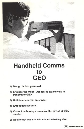
In April, a secure, handheld satellite transmitter prototype built by a division
of Motorola (now part of General Dynamics) is demonstrated.
In July, at the Second International Mobile Satellite Conference, Geostar reports
that it is currently providing more than 65,000 position reports (derived via
LORAN-C) and messages each day to more than 70 commercial and government customers.
Mobile units transmit a burst containing position and status information, as well
as an alphanumeric message of up to about a hundred characters, at 1618.25 MHz in
the band allocated for RDSS. The transmission is a direct sequence, spread
spectrum signal, with a duration of 20 to 80 milliseconds per transmission
packet. This signal consists of 15.625 kilobit per second data, rate-1/2 encoded
for forward error correction, spread by a direct sequence pseudo-random noise
code operating at 8.000 megabits per second. The spread signal is BPSK modulated
and occupies about 16 MHz of bandwidth. The RDSS relay on board the host
domestic fixed satellite retransmits these signals to Geostar's central earth
station and operations center in Washington, D.C., using the conventional
11.7-12.2 GHz domestic satellite band.
A C-band (4/6 GHz) link using commercial fixed satellite transponders provides
communications from Geostar central to the mobile terminals. This outbound link
to the mobile terminals is a continuous signal, which is framed and contains
message packets addressed to mobile users. This signal consists of 1200 bit
per second data, rate-1/2 encoded for forward error correction, spread by a
direct sequence pseudo-random noise code operating at 1.2288 megabits per
second. The spread signal is BPSK modulated. Two such signals can be transmitted
over the same transponder. Geostar is currently using an uplink earth station
provided by GTE Spacenet to transmit this signal to the satellite, with
landline connections between that earth station and Geostar's operations center
in Washington, D.C.
Also in July, Geostar is granted U.S. patent 4,943,974 for Detection of burst
signal transmissions. The Geostar inbound (transceiver to ground
station "hub") transmission was a direct sequence spread
spectrum burst which consisted of an acquisition aid ("preamble")
and a payload. The acquisition aid was a configurable sequence of
pseudo-noise (PN) chips which allowed a hub burst receiver to detect the
transmission. The payload contained convolutionally encoded user data.
|
| |
| 1991 |
|
In a report entitled Aeronautics and Space Report of the President,
1989-1990 Activities from the National Aeronautics and Space
Administration (NASA), the following Geostar mentions were made:
Geostar Positioning Corporation commenced two-way start-up
radiodetermination satellite service in the United States in 1989.
The radiodetermination satellite service (RDSS)
continued to develop in 1989. This service was authorized
in 1986 and allows subscribers to determine latitude,
longitude, and altitude, and to exchange brief coded
messages using hand-held or vehicle-mounted transceivers.
Geostar Positioning Corporation, the licensee in this
service, continued construction of its three dedicated
RDSS satellites, which are to operate in the frequency
bands allocated for RDSS. Geostar also commenced two-
way start-up service in 1989 by using capacity on
domestic fixed satellites on a non-interference basis.
Geostar declares bankruptcy in February.
A July report from the U.S. Congress, Office of Technology Assessment,
entitled Technology Against Terrorism: The Federal Effort,
stated:
This agency [U.S. Customs Service] does not engage in much original research
directly related to counter terrorism. However, Customs
has supported considerable work in the area of drug
detection and interdiction, some of which is of ancillary
utility to the war on terrorism. The largest portion of the
R&D money mentioned above (about $3 million per year)
has been devoted to development of a covert remote
locating system (known as Geostar). Signals from a small
device hidden on an object will be picked up by a pair of
Earth satellites. By triangulation, the location of the object
can be determined. This project is a cooperative effort
with other agencies and groups, including the TSWG
[Technical Support Working Group].
|
| |
| 1992 |
|
Motorola, deep in the planning stages for their Iridium project,
purchases Geostar's RDSS licenses at Geostar's bankruptcy auction
for $50,000.
|
| |
| 1993 |
|
In September, the Bureau of Land Management (BLM) produces a
document that includes a brief description of the bureau's experience
with Geostar:
Several commercial two-way (active) positioning systems have been in the
planning stages. One, GEOSTAR, had undergone some initial testing, but
the corporation went out of business. GEOSTAR proposed the first
continentwide communication and positional system. It was targeted at the
transportation industry for identification, location monitoring, and
communication to commercial vehicles. Electronic map displays in
automobiles were a target application. GEOSTAR planned access through a
subscription service. Accuracies were expected to be 10 to 50 meters.
BLM used the communication component of GEOSTAR's first satellite to
successfully test aircraft flight-following to assist in more accurate
aircraft locations in emergencies. This very successful test used
LORAN C-derived coordinates transmitted from aircraft to the GEOSTAR
satellite, then to a ground station for display on a computer screen.
Testing of GPS positions for flight-following was started with GEOSTAR
went out of business (BLM, 1991). BLM plans to continue aircraft
flight-following using other communications satellites.
|
| 1991 |
|
Newcomb Communications is founded in New Hampshire.
|
| |
| 1993 |
|
FCC authorizes Newcomb Communications to operate 10,000 mobile units
that provide one-way position reporting using the Spacenet-3 satellite.
This authorization was set to expire when the first "Big LEO"
began to operate, since the spectrum in question had been
reallocated to the Mobile Satellite Service (MSS).
|
| |
| 1994 |
|
In December, Newcomb demonstrates their mobile transceivers on the
Cajun Queen river boat and the Coast Guard cutter Saginaw,
operating in and around New Orleans, Louisiana.
|
| |
| 1995 |
|
In November, representatives from the U.S. Coast Guard Research and
Development Center present a paper describing the results of technology
tests related to automated dependent surveillance. That paper contains
a positive evaluation of Newcomb's system:
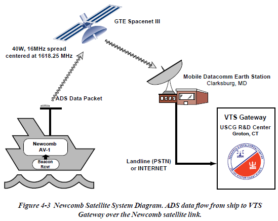
The final communications system of the three to be discussed
is the Newcomb Satellite system. This is a geostationary
satellite system using the RDSS band (1608.1626 MHz) and
is a successor to the defunct Geostar system.
4.3.1 Newcomb System Operation.
The shipboard equipment consisted of a Newcomb CP-1
direct sequence spread spectrum (DSSS) satellite transmitter
with integrated GPS receiver. The same radiobeacon receiver
used in the previous two systems was used here to provide
differential corrections to the GPS receiver internal to the
Newcomb CP-1. The CP-1 was connected to a small, flat Lband
antenna and a very small, flat GPS antenna.
The ADS data was generated by the internal GPS receiver
and then automatically transmitted by the CP-1 as a data
packet every 10 seconds. The Newcomb CP-1 transmissions
were relayed by a geostationary satellite (GTE Spacenet III)
and received at the Mobile Datacomm (MDC) satellite earth
station in Clarksburg, MD where they were placed into the R
& D Center mailbox on the MDC computer system. A Link
Control Computer at the VTS Gateway was connected to the
MDC computer either via modem and the PSTN or via
Internet and pulled data reports out of the R & D Center
mailbox in real-time. This information flow is illustrated in
Figure 4-3.
The analysis of the data showed the system to work very
well. Each data packet transmitted was sequentially numbered
by the CP-1. Thus it was possible to measure the
percentage of packets making it to the VTS Gateway.
Overall, the figure was about 96%. The actual system
performance was better than this though. It was discovered
that the .omnidirectional. antenna had two nulls in the
radiation pattern. Further testing and analysis showed that
packets were received 99.9% of the time except when
operating in the pattern nulls.
This system has the largest capacity of the three tested. Due to
the extremely short transmissions and the nature of spread spectrum
modulation a very large number of users can be supported in this bandwidth
(>100,000). The real limit on the number of users is the processing
power of the Earth Station. Currently this is around 20 transmissions
per minute according to MDC, but based on our use of the system, this
is underestimating the capability. There is also the future potential
to increase capacity by using multiple earth stations, each one with
it's own pseudo-noise (PN) code.
4.3.3 Newcomb System Conclusions.
The Newcomb system appears to be a good candidate for ADS based VTS
systems. There are many advantages: The system has a high capacity as
discussed above, there is room for future expansion by adding new earth
stations using different PN codes for the DSSS signal, equipment is
small and easily installed, and there is no infrastructure to create
or maintain. Furthermore, a single Link Control computer at the VTS
Gateway can handle any number of Newcomb transmitter equipped vessels,
communications service costs are lower than for cellular, reports
are received very quickly, and due to the high capacity of the system
mobile units can report in at shorter intervals. Finally, the satellite
footprint is CONUS plus 200 miles offshore, so the same system can be
used all over the USA without any CG maintained shore installations. The
only disadvantages to the system are the cost of the shipboard equipment
and the cost of the MDC service which is still fairly expensive although
it is less expensive than cellular.
|
| |
| 1996 |
|
Newcomb completes a demonstration for the U.S. Coast Guard.
A subsequent report summarizes the development environment for both
Newcomb and Mobile Datacom Corporation:
The AV-2 transmit/receive mobile terminal design requirements and
product development plans were based on the experience of the founders
of Newcomb Communications in the application of the Geostar system to
transportation operations on land, sea, and air. As a small start-up
company with limited resources and financing, a pragmatic approach was
adopted that recognized the limited resources, lack of test equipment,
and budget constraints. These constraints, however, were to a large part
offset by the knowledge, experience, and close-knit working relationship
of the design team.
The report includes an example of how messages are encoded:
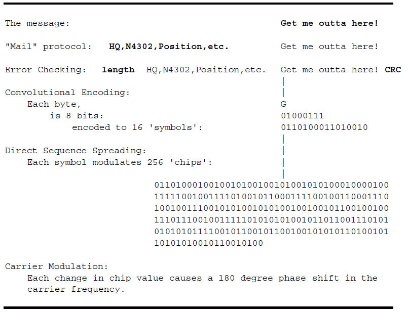
Newcomb also provides a description and status of the
then-current Mobile Datacom hub:
Newcomb Communications began developing its own Fixed Earth Station
(FES) to operate in conjunction with the Newcomb mobile terminals. The
FES reception and decoding subsystems were developed and a prototype
was demonstrated to the Coast Guard and Army in May of 1993. This
demonstration included the ability to detect, decode, and display messages
transmitted by a CP-1 unit via the Spacenet III satellite using Geostar PN
coding and the Mobile Datacom (MDC) Earth Station (located in Clarksburg,
MD). Then, using a different PN code, the same demonstration was given
using the Newcomb prototype FES.
Subsequent to this major milestone, the Company established an agreement
with Mobile Datacom Corporation (MDC) whereby the Company would use MDC's
Earth Station and satellites. This provided the opportunity to focus
the Company's engineering resources on the development of the mobile
terminal products, while MDC addressed the operation of the satellite
and Fixed Earth Station.
The MDC Earth Stations were originally built by COMSAT for the
Geostar system in the late 1980's. The technology used for signal
acquisition/decode is Surface Acoustic Wave (SAW) delay lines. SAW delay
lines were used because Digital Signal Processing (DSP) devices were not
yet available. MDC has re-installed this FES/Hub system on the COMSAT
campus at Clarksburg, MD. They have also installed a modulator for the
outbound (C-band) messaging at a commercial common carrier earth station
located in Carteret, NJ. The facility is connected to the MDC Hub by a
leased telephone line.
|
| 2000 |
|
In February, Newcomb Communications becomes Outerlink Corporation.
|
| |
| 2002 |
|
In June, the FCC grants Outerlink a three-year license for 20,000 full-duplex transceivers to operate over
the AMSC-1 satellite. These transceivers receive a 5 kHz forward link between 1530 and 1559 MHz and transmit
a 3.5 MHz-wide direct sequence spread spectrum (DSSS) burst between 1638.5 and 1642 MHz.
|
| |
| 2004 |
|
In January, Digital Angel Corporation acquires Outerlink Corporation.
|
| |
| 2006 |
|
In June, Outerlink wins a $3.2 million contract from the South Carolina Army National Guard
to demonstrate their Automatic Flight Following System (AFFS).
|
| |
| 2007 |
|
Paul Newcomb leads a group of employees to buy back Outerlink from Digital Angel Corporation.
|
| |
| 2011 |
|
In March,
with their business focused on aviation,
Outerlink exhibits several products and services at HeliExpo in Orlando.
At this point in time
Paul Newcomb is dividing his time between New England and Florida.
|
|
|
MOBILE DATACOM CORPORATION
|
| 1993 |
|
 Mobile Datacom Corporation is started as a spin-out from
Maryland-based Comsat Corporation, headed by former
Comsat Systems Division President Joel Alper. It is headquartered
on the campus of Comsat Corporation in Clarksburg, Maryland on the
second floor of the Satellite Control Facility (SCF).
Mobile Datacom Corporation is started as a spin-out from
Maryland-based Comsat Corporation, headed by former
Comsat Systems Division President Joel Alper. It is headquartered
on the campus of Comsat Corporation in Clarksburg, Maryland on the
second floor of the Satellite Control Facility (SCF).
Comsat was a Geostar creditor and had acquired much of Geostar's
equipment and technology from the bankruptcy court.
This included the RDSS
hub and computers as well as an inventory of
Hughes-built mobile L-band transmitters and
Kenwood-built C-band mobile receivers.
|
| |
| 1995 |
|
FCC authorizes Mobile Datacom Corporation to operate 10,000 mobile units
that provide two-way position reporting and data communication
using geosynchronous satellites Spacenet-3 and GSTAR-3.
This effectively reinstituted Geostar's service.
As with the Newcomb license,
this authorization was also set to expire when the first "Big LEO"
began to operate. Motorola's Iridium satellite network was
the primary concern.
The system was publicly described as follows:
Inbound
- The transmitter fires a direct sequence spread spectrum signal at 1.6 GHz (L Band)
lasting no longer than 80 milliseconds.
- This signal is received by a geostationary satellite with L band capability
(Spacenet 3R)
and transponded to the ground station at Ku band.
- The signal is acquired and decoded at the ground station by one of two
hub units. The decoded packet is then delivered to a pair of
Hewlett-Packard 9000 series computers (known internally as "Ren" and "Stimpy")
for further processing and delivery to the customer.
Outbound
- A packet destined for a mobile unit is uplinked to a geostationary C band
satellite (Comstar D4). The mobile receiver is locked to the C band
carrier and demodulates incoming packets in a manner similar to the inbound path.
Features and Benefits
- Transmissions have superior LPI/D (Low Probability of Interception/Detection)
characteristics, making them an excellent choice for clandestine messaging
in a hostile environment.
- Inbound and Outbound channels are available to all units at all times,
allowing for instantaneous two-way messaging.
Mobile Datacom begins work on a vehicle tracking and messaging
system for the United States Army. This effort will become the
Movement Tracking System, a $419 million
contract awarded to the company in 1999. Preliminary equipment
and software is tested at Fort Hood, Texas and demonstrated at
the US Army's National Training Center (NTC) at Fort Irwin, California,
achieving some of the highest asset utilization scores ever recorded.
|
| |
| 1996 |
|
Mobile Datacom continues to demonstrate the MTS concept in July
at the US Army's National Training Center (NTC) at Fort Irwin, California.
The system is used heavily during exercises and is a critical link to
coordinate medical helicopter rescue after a vehicle accident where no
other communications links were available.
|
| |
| 1997 |
|
In September Mobile Datacom is awarded a two-stage development contract
from the Defense Advanced Research Projects Agency (DARPA).
The first stage of the contract provides funding for the development of
a second-generation satellite-based network.
 Also in September,
Mobile Datacom completes an Advanced Concepts and Technology (ACT) II Program
for the US Army Combined Arms Support Command (CASCOM) after a final convoy demonstration
from Fort Stewart, Georgia to the Port of Savannah.
Also in September,
Mobile Datacom completes an Advanced Concepts and Technology (ACT) II Program
for the US Army Combined Arms Support Command (CASCOM) after a final convoy demonstration
from Fort Stewart, Georgia to the Port of Savannah.
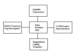
The ACT II demonstration integrates
a Radio Frequency Identification (RFID) interrogator,
a SAE J1708/J1587 Vehicle Data Bus interface and
a ruggedized laptop computer
with a GPS-equipped satellite transceiver on a mobile military platform.
The computer provides a moving map display and a two-way text messaging
capability in a software program called MTS Messenger.
Data transmitted from each platform is collected at a satellite Earth Station in
Ellicott City, Maryland and made available on a series of web pages.
Position and status information collected from each vehicle, processed
in a software application called BField (short for battlefield),
is broadcast back out via satellite to all vehicles.
|
| |
| 1998 |
|
 Mobile Datacom begins the financial legwork in anticipation of
an Initial Public Offering (IPO). As part of the IPO process,
a business plan is circulated in February that includes highlights of
the second-generation network:
Mobile Datacom begins the financial legwork in anticipation of
an Initial Public Offering (IPO). As part of the IPO process,
a business plan is circulated in February that includes highlights of
the second-generation network:
Associated with the development of its next generation system are two
major enhancements to the Mobile Datacom Network:
1. Multi-platform operation
2. Virtual Private Network Services
Through funding provided by a recently awarded contract from the
U.S. Government's Defense Advanced Research Project Agency (DARPA),
as supplemented by investor funding, Mobile Datacom will develop
its next generation system to be multi-platform capable. This will
make Mobile Datacom the only service provider in the business able
to offer customers the choice of which satellite system to use with
the same hardware/software combination. This will be accomplished by
designing the MDC spacelink and physical protocol layers to accommodate
other satellite relays as they become available while leaving external
interfaces to the mobile terminal and the satellite gateway the same.
Systems through which the Mobile Datacom Network will be able to operate
include American Mobile Satellite Corporation (AMSC) (available today),
TMI of Canada (available today), Globalstar, Odyssey, and other systems
in which the satellite functions as a bent pipe relay, permitting the
transmitted signal to pass through the satellite without any processing.
Since many customers and VARs want their own private networks, the
Company will provide a wide range of virtual private network services.
The Company's network architecture allows it to offer customers their
own piece of the system, to manage as they choose.
In April, technical work begins on the design of the next generation satellite transceiver,
later named the MT-2010.
In September, the U.S. Army Training and Doctrine Command (TRADOC)
approved the operational requirements for MTS. Soon after
the Program Executive Office (PEO) for Standard Army Management
Information Systems (later the PEO for Enterprise Information Systems)
received program management responsibility for MTS.
In October, Comtech Telecommunications of Melville, New York, purchases Mobile Datacom.
|
| |
|
COMTECH MOBILE DATACOM CORPORATION
|
| 1999 |
|
In June, the U.S. Army awards Comtech Mobile Datacom a $419 million IDIQ contract for Movement Tracking System (MTS),
a satellite-based, logistics-oriented tracking and messaging system.
|
| |
| 2000 |
|
In January, Comtech Mobile Datacom begins work with the Dominguez Hills division of TRW (later to be
purchased by Northrop-Grumman) to determine a way to provide
satellite service to the U.S. Army Force XXI Brigade and Below (FBCB2) program using
existing MTS L-band transceivers. At this time, the FBCB2 program relied solely on terrestrial,
line-of-sight radios to communicate in a mesh network, however when a vehicle moved out of sight it would
lose connectivity and drop out of the network. Satellite-based networks held the promise of greatly
improved network coverage and connectivity.
In April, MTS passes operational testing with the 180th Transportation
Battalion, 13th Corps Support Command (COSCOM), at Fort Hood, Texas.
|
| |
| 2002 |
|
In October Brigadier General Mazzucchi, as the Designated Approval Authority (DAA),
signs the Initial Authority to Operate (IATO) paperwork for FBCB2 Blue Force Tracking (BFT).
This clears the way for Comtech hardware and software to be used in Operation
Enduring Freedom (OEF).
|
| |
| 2003 |
|
In July, Joel Alper retires. Under his leadership, Mobile Datacom grew from a startup to a significant
player in military satellite communications, having developed a new satellite system and won
two major Army contracts (MTS and FBCB2 BFT). Over the subsequent eight years,
these contracts would bring in $1.5 billion of revenue to the company. His contemporaneous
analysis of Comtech Mobile Datacom's future would prove prescient
as he commented in private correspondence on a then-current Army analysis of the BFT system:
[The article] is very
interesting and confirms my view of what the future holds for systems
such as Comtech's.
To our very great credit, the satellite system, and
the operating software and applications worked. Now, the warfighters
have a taste for what is available, and a very clear idea of
shortcomings. That is to say, they see what is being done, and now they
understand how it can work for them, were it to have been designed with
their specific needs in mind. While this always comes down to questions
of time and money, there is going to be a big push to put in place the
systems that work the way the warfighter wants them to work, since now
it's only a matter of, as I indicated, time and money. Time isn't a
factor, since they can use what they've got in the interim, and money,
well, there's a lot going to be spent, so why not on bandwidth and software.
The challenge comes from the possibility that the future system will not
be a derivative of the exisiting system, but the result of a totally new
development, like JTRS [Joint Tactical Radio System].
That could come out of NG [Northrop-Grumman], or GD [General Dynamics],
or any of the large (or small) systems integrators. Comtech will need to get on board, somehow,
or the train will leave them at the station.
[This] article is the first I've seen, and undoubtedly not the
last, reflecting the real needs. And those needs will be met. The Army
isn't going to grow, so it's the systems that will have to maintain the
effectiveness of the small fighting force. Great selling point if you
can make the connection.
J. Preston Windus, Jr., a Comtech corporate financial officer, takes over management of
the Mobile Datacom division.
In September, installation of MT-2011 satellite transceivers NATO vehicles in Kosovo begins.
These units will provide messaging and location data for peacekeeping operations.
Also in September, a thesis from a Naval Postgraduate School student discussing tracking technologies contains this:
Position location is provided by the Globalstar constellation rather via
the GPS satellite system. The satellites calculate position using radio
frequency (RF) time difference of arrival (TDOA), frequency difference
of arrival, angle of arrival or a combination of the geolocation
methodologies. Accuracy of the positions is up to 10 km.
Incidentally, this type of positional technology is similar to Radio
Determination Satellite Service (RDSS) created by GEOSTAR in the 1980s
and currently owned by Comtech Mobile Data Corporation (CMDC). RDSS
establishes geolocation by radio frequency TDOA using two or more
satellites in geosynchronous orbit. CMDC currently uses GPS along with
the two-way communication capability of RDSS to provide location data
in its movement tracking system service, which is enabled by Inmarsat
constellation. Although GPS technology seems to be the favorite for
geolocation, RDSS is worth investigating.
A clarification to the thesis would note that CMDC licensed Geostar
technology from Comsat Corporation, who owned the rights after Geostar's
bankruptcy.
| | |
| 2004 |
|
 By May there are about 3,700 MTS-equipped vehicles
operating around the world, including more than
2,000 in Iraq and Kuwait.
By May there are about 3,700 MTS-equipped vehicles
operating around the world, including more than
2,000 in Iraq and Kuwait.
|
| |
| 2005 |
|
In April, Windus retires and is replaced as President of Comtech Mobile
Datacom by Daniel S. Wood, a former Group Director of Finance, Director
of Marketing and Strategic Planning, and Director of Contracts at EDO
Corporation, a supplier of military and commercial products and services,
where he had been for 15 years. The press release issued at the time
explains,
"Dan Wood has the ideal background and skill set to take over the reins
from Pres Windus at Comtech Mobile Datacom. His strong operations and
finance experience is very similar to that of Pres."
Like Mr. Windus, his background is financial rather than technical
and is lacking in any significant mobile satellite industry experience.
|
| |
| 2006 |
|
In May, the FBCB2 BFT Program Office at Fort Monmouth, New Jersey
issues a "sources sought" notice for
[C]ommercial L-band bandwidth, network management services, engineering
design and development services, and L-band satellite transceivers
for Fiscal Year 2007 (FY-07) and beyond supporting US Army FBCB2 BFT
operations Worldwide.
The notice includes the following request:
Optional - A source of supply for engineering services capable of reverse
engineering the firmware contained within the CMDC MT-2011 and CMDC hub
and packet switch equipment to provide a more secure and more capable
waveform to support FBCB2 BFT operations. NOTE: The Government does not
own the design rights to the CMDC MT-2011 transceiver, CMDC hub equipment,
or CMDC packet switch, nor does it have any drawings or documentation
that describes the design and operation of this equipment. The Government
does own CMDC MT-2011 transceivers and CMDC packet switch equipment that
can be provided for purposes of reverse engineering.
Also in May, Comtech corporate tells the Government that it had not agreed
to allow CMDC to license any proprietary information to the Government
at any price for use in future competitive procurements. At time,
CMDC estimated that the value of their ongoing business operations,
and the potential risks associated with releasing the proprietary data
to competitors in the industry would be valued (if a value were to be
assigned) in excess of $100 million.
|
| |
| 2007 |
|
In April, FBCB2 Prime Contractor Northrop-Grumman awards an initial $9.3 million contract to
California-based ViaSat, Inc., a Comtech competitor, to develop a faster satellite-based Blue Force Tracking system.
In August, the Federal Communications Commission (FCC) issues a
Letter of Inquiry ("LOI") regarding whether CMDC
violated section 301 of the Communications Act of 1934 and sections 25.102, 25.117, 25.136(d)
and 25.276(a) of the Commission's Rules by modifying and operating its
MET [Mobile Earth Terminal] system without appropriate authorization.
|
| |
| 2008 |
|
In September, Comtech enters into a consent degree with the Federal Communications Commission (FCC):
The Enforcement Bureau ("Bureau") and Comtech Mobile Datacom Corporation
("CMDC"), by their authorized representatives, hereby enter into this
Consent Decree for the purpose of terminating the Bureau's investigation
into whether CMDC violated section 301 of the Communications Act of 1934,
as amended ("Act") and sections 25.102, 25.117, 25.136(d) and 25.276(a) of
the Commission's Rules by modifying and operating its mobile earth
terminal ("MET") system without appropriate authorization.
As part of the consent decree, CMDC makes a
"voluntary" contribution to the United States Treasury in the amount of $25,000 and
is required to make regular reports regarding technical parameters of system operation.
|
| |
| 2009 |
|
In February, the MTS Program Office releases a Request for Information (RFI) seeking
alternatives to Comtech.
Sixteen (16) companies responded to the RFI, including Comtech and Northrop-Grumman,
the Prime Contractor for FBCB2. Analysis of the Northrop bid included this:
Respondent proposes the adoption of the Battle Command
Product Line (BCPL) Logistics software variant, Movement Tracking System. Enhanced
Software (MTS-ES), (currently undergoing test), to stand up a new NOC [Network Operations Center]
to host MTS running
MTS-ES software, to ramp up the system as quickly as possible, and to undergo a transition
period from legacy NOC to the new proposed NOC. Separate and apart from this proposal, the
current plan is for MTS to adopt MTS-ES as its future software (assuming successful testing and
user acceptance). However current schedules do not project the availability
of MTS-ES until second quarter FY2011. The current MTS contract ends July 2010 which is 6
plus months before MTS-ES is projected to be available.
[...]
With successful testing, acceptance, and availability of this software, MTS will no
longer need to sole-source CMDC's proprietary components or require a prime contractor to use
CMDC as its sub-contractor. Once the BCPL software is released, it will allow for MTS to have
open standards, and this is expected to significantly increase competition for future contracts.
In April, the FBCB2 BFT Project Manager issues a Market Survey seeking sources for:
L-band bandwidth, network management services, engineering design and
development services, and the procurement of BFT-2 L-band satellite
transceivers, during the years 2010 - 2015 and beyond supporting PM
FBCB2 BFT operations worldwide.
The PM seeks to procure the hardware and acquire the services, using multiple awards
of Indefinite Delivery Indefinite Quantity (IDIQ) contracts.
...
The total dollar value of each contract would be $477M.
Starting in 2010 thru 2015, the Army wants to replace the current BFT-1 CMDC
equipment with improved equipment that provides an order of magnitude improvement in
data throughput.
In September, CMDC repeats to the Government that the value
of its ongoing business operations, the Government-wide application of Government Purpose
License Rights, and the potential risks associated with releasing the proprietary data to unlimited
industry competitors, would necessitate a minimum license price of $125 million with any data,
documentation or other information provided in an "as is" condition with no warranties or
guarantees associated with the license.
The Government immediately determines that these terms and conditions are unacceptable.
|
| |
| 2010 |
|
In July, the U.S. Army awards a $477 million IDIQ contract for the next generation FBCB2 Blue Force Tracking system (called BFT-2)
to ViaSat, Inc. rather than incumbent Comtech Mobile Datacom. In response to this loss,
Comtech stock (ticker symbol CMTL) drops by nearly a third in a single day, representing the extent to which the market valued
the Army contract and the division's relationship with the military.
Also in July, a Memorandum of Understanding (MOU) is signed that places
the Movement Tracking System (MTS) office under PEO C3T, and thus
under FBCB2.
|
| |
| 2011 |
|
In May, the Movement Tracking System (MTS) Product Office offically moves
under the Army's Program Executive Office (PEO) Command, Control and
Communications-Tactical (C3T).
Also in May, Comtech was notified that their BFT-1 contract was selected
for a post award audit by the Defense Contract Audit Agency ("DCAA"). A
post award audit (sometimes referred to as a Truth in Negotiations Act
or "TINA" audit) generally focuses on whether the contractor disclosed
current, accurate and complete cost or pricing data in the contract
negotiation process pursuant to Federal Acquisition Regulations
("FAR").
At the end of June, after multiple rounds of layoffs, Comtech Mobile Datacom ceases providing commercial satellite service over North America.
For the fiscal year ending July 31, payments from the BFT-1 and MTS contracts accounted for 40 percent of Comtech corporate revenue.
Since 1999, Comtech delivered about 139,000 BFT-1 mobile satellite transceivers and 47,000 MTS units.
In August, Comtech corporate offers to sell the rights to CMDC's intellectual property to the Government for $120 million.
The Government declines.
With the Army indicating it would contract for satellite capacity directly rather than through Comtech,
during a September conference call to investors, Comtech officials indicated they would charge the government
a separate fee for the use of the company's intellectual property.
Comtech makes "The GMI Risk List" for October, 2011 with the following
analysis from GMI Ratings:
The defense industry in general poses social concerns for some
investors. At defense contractor Comtech, the average director tenure is
18 years and only one director is under seventy; the board also lacks
diversity with regard to gender. High average tenures and ages, taken
together, suggest entrenchment planning concerns. Remuneration decisions
are only loosely linked to performance, which has lagged peers and the
S&P 500 for the last five years. Finally, a number of accounting
flags suggest that expenses may be understated or possibly capitalized.
Also in October, after a period of unexplained absence, Dan Wood resigns
as President of Comtech Mobile Datacom. Management of the division is
to be handled by Comtech AeroAstro, a sister division located in Ashburn, Virginia.
According to a Schedule 14A (Proxy Statement) filed in November 2010 with the
Securities and Exchange Commission (SEC), in addition to his $314,140 base salary,
Mr. Wood received a 2010 non-equity incentive award of $750,000 which
was primarily based on the level of fiscal 2010 pre-tax profit achieved
for the business operations for which he was responsible and the ECC's
[Executive Compensation Committee] evaluation of his overall performance.
The evaluation includes this:
The ECC considered the fact that the subsidiary Mr. Wood supervises was
not selected as the program manager and vendor for the Blue Force Tracking
2 ("BFT-2") program because a third party vendor bid a price that was 50%
lower than the price submitted by Mr. Wood's subsidiary. Ultimately, as
a result of the expected future decline in sales and profits related to
BFT-2, the Company recorded a goodwill impairment charge in its fiscal
2010 results.
Mr. Wood was also awarded 20,000 shares of CMTL stock in June 2010,
with an estimated value of $216,354. His total reported compensation
for the 2010 fiscal year was $1,451,726.
In addition, at the time of his departure Mr. Wood sold 42,000 shares of
CMTL, netting $1,332,240.
Later in October, Comtech corporate tersely announces his departure and names
his replacement as Paul Lithgow. From the press release,
Fred Kornberg, Chairman and Chief Executive Officer of Comtech
Telecommunications Corp., said:
"As President of both CMDC and AeroAstro, Paul is the perfect candidate
to further reposition our mobile data communications segment. I believe
that Paul's experience in establishing AeroAstro as a leader in the
emerging microsatellites industry will be beneficial as we continue to
adjust our mobile data communication segment's business strategy."
"I believe that the people and technology at CMDC are second to none
and I am confident that Paul and the team will position our mobile data
communications segment for future growth and continued profitability."
A December Comtech investor presentation confirms the success of the original
Mobile Datacom work with this line:
Fiscal 1999 - Mobile Datacom - generated over $1.5 billion of revenue over 10 years
The presentation summarizes Comtech's predicament with this:
After 10 Years of Rapid Growth, Revenues in Fiscal 2012 are Expected to
Materially Decline as MTS & BFT-1 Programs Go Into Sustainment Mode
The presentation also admits the transition (although not referring to it
as such) of the Movement Tracking System (MTS) Network Operations Center
(NOC) from Comtech's Germantown facility to the FBCB2 BGN at Aberdeen
Proving Grounds.
Subsequent to October 31, 2011, we received an
order for $3.8 million to support the integration and
establishment of an MTS network operations center
within the existing BFT facilities by July 9, 2012.
| | |
| 2012 |
|
In January the Army awards Comtech short-term contracts for equipment and
service. The intent of the Army is to acquire commercial satellite capacity
through the DISA-GSA Future COMSATCOM Services Acquisition (FCSA) program
rather than through Comtech.
Through January 31, 2012, Comtech received $378,009,000 in total
orders under their BFT-1 contract.
During a March 9 investor's conference call, Chairman Fred Kornberg repeats
his demand for payment from the Army and further maintains that even if the
Army moves to other vendors for BFT-2 and satellite service, Comtech will
still demand payment for the use of their "intellectual property."
At the end of March, with a 31 March contract expiration looming,
the Army agrees to a service extension with Comtech. The contract
includes a list of intellectual property claims, for which Comtech
will be paid $10 million each year. From an April 2 press release:
The specific terms and conditions related to the IP license are covered
by a separate licensing agreement which provides for an initial licensing
period that begins April 1, 2012 and ends March 31, 2013 and provides for
annual renewals, at the U.S. government's option, for up to a five-year
period, after which time the U.S. government will have a limited
non-exclusive right to use Comtech's IP for no additional IP licensing fee.
The first order under this contract established the IP license fee
as $10.0 million for the initial period. This amount is separate
from any services, management or operations costs.
In April, BFT-2 equipment from ViaSat begins official fielding, marking
the start of a planned replacement program of BFT-1.
In July, Comtech shuts down the AeroAstro division and lays off about
50 employees. In October some of the assets of AeroAstro are
sold to San Diego-based Space Micro.
In a Fourth Quarter investor presentation, Comtech again highlights their
"Strong Track Record of Successful Acquisitions" with the inclusion of
the line "Fiscal 1999 - Mobile Datacom - generated over $1.5 billion of
revenue over 10 years." There is no mention of how Mobile Datacom created
that success or of the individuals (now long departed) who made it possible.
In a November proxy statement (Schedule 14A), Comtech acknowledges some of
the financial effects of losing the BFT-2 competition:
Like it did in fiscal 2011, our ECC decided to award lower total fiscal
2012 compensation to our NEOs (including our CEO), in part, as a result
of the continuing impact to our business of the July 2010 decision by
the U.S. Army to award the Blue-Force Tracking-2 ("BFT-2") contract
to a competitor, and the U.S. Army's related decision to combine its
Movement Tracking System ("MTS") program with the BFT program. While the
U.S. Army's decisions did not have an immediate impact on our financial
results, the July 2010 announcement of the loss of the BFT-2 contract
to a competitor resulted in a 31.9% one-day drop in our stock price
(which has not yet been fully recovered) and its loss will negatively
impact our comparative financial results for several years.
According to a filing made by Comtech to the Securities and Exchange Commission (SEC),
in December Comtech is informed that a preliminary report by the government auditor
(the audit conducted by the Defense Contract Audit Agency (DCAA) and the Defense Contract Management Agency)
concluded that Comtech's pricing methods under the BFT-1 contract were unacceptable,
and that the company would be asked to reimburse $11.8 million plus $2.3 million in interest.
| | |
| 2013 |
|
In June, Comtech receives the expected order from the U.S. Army for BFT-1 sustainment. The $15.8 million
order includes the second year intellectual property charge of $10 million. In conjunction with a
previous $5 million order, the remaining $10.8 million covers sustainment services including staffing
of the BGN at Aberdeen and telehousing costs for hub equipment located at various satellite earth stations.
In October, Comtech sells its Sensor-Enabled Notification System (SENS) to Orbcomm, Inc. for $2 million.
Comtech reported in a filing with the Securities and Exchange Commission (SEC) that SENS generated
about $4.6 million in revenue in the previous fiscal year.
The sale includes hardware, network equipment and web platforms. SENS originated out of
the now-defunct AeroAstro division and was designed as a one-way data delivery service
using the inbound (mobile to ground station) links of first-generation Globalstar satellites.
In November, Comtech announces the departure of Paul Lithgow, who returns to Arizona to pursue his interest in small satellites.
At this point Comtech Mobile Datacom has a staff of about 60 employees and 25 contractors.
The announcement includes this:
Paul Lithgow, President of Comtech Mobile Datacom Corporation, will also
be leaving Comtech to return to Arizona and the aerospace industry. Paul
joined Comtech in 2008 as part of AeroAstro (which was acquired in
connection with the Radyne acquisition). Paul served as President of
Comtech AeroAstro until it was wound-down in 2012, and had also become
President of Comtech Mobile Datacom the previous year.
The announcement also notes the return of Pres Windus, now 70 years old and eight years into retirement:
Pres Windus will be returning to the role of President at Comtech
Mobile Datacom, effective November 6, 2013. Pres previously served as
the President of Comtech Mobile Datacom for three years between 2002
and 2005. He also served in various other capacities during his 29-year
tenure at Comtech. Paul Lithgow will be available for consultation to
ensure a smooth transition.
Mr. Kornberg noted, "Paul Lithgow successfully stabilized the Mobile
Datacom business over the past couple of years. We wish him the best as he
returns to Arizona and avoids the cross-country commute that he has made
over the past several years. We welcome back Pres Windus to Comtech. Pres
knows the Mobile Datacom business, as well as Comtech as a whole. As such,
I expect a smooth leadership transition in the coming weeks."
| | |
| 2014 |
|
In August, Comtech Telecommunications Corporation confirms publicly
that it is "exploring strategic alternatives" that could
include a merger or sale of the company.
Comtech stock (CMTL) rises over the next three months and reaches
a 52-week high of just over $40 per share.
In December the company announces:
After considering various strategic alternatives to enhance shareholder
value, including a possible merger or sale of the Company, the Board
has determined that the interests of the Company and its shareholders
will be best served by the Company remaining independent.
Within a week of the announcement the company stock plunges to
just over $30 per share.
Prepared in November,
the Comtech 2014 Annual Report shows the precipitous drop in revenue
of the Mobile Datacom segment over the past five years:
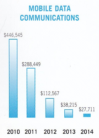
From the report:
Our primary goal in the mobile data communications segment continues to
be to provide the U.S. Army with outstanding support. Doing so should
position us well to participate in any next-generation BFT platform.
In fact, we have recently responded to two government RFI's that are
effectively requesting alternatives to the BFT-2 transceiver. One is for
a BFT-2.5 L-band transceiver to replace the current BFT-2 transceiver.
The second RFI is for a dual frequency transceiver operating at both
L-band and X-band.
In December, the company announces that Dr. Stanton D. Sloane will become
CEO and President of Comtech Telecommuncations Corporation no later than
February 1, 2015. Fred Kornberg will continue as Executive Chairman of
the Board of Directors.
| | |
| 2015 |
|
After years of declining revenue, in July Comtech announces that it is folding
the Mobile Datacom division into sister division EF Data. The press release at
the time gives the following explanation:
To improve company-wide operating efficiencies and offer more innovative and
integrated solutions to our customers, Comtech will fully integrate the activities
and business of its Germantown, Maryland-based subsidiary, Comtech Mobile Datacom
Corporation, with its Tempe, Arizona-based subsidiary, Comtech EF Data Corp.
|
|
|
Radiodetermination Satellite Services and Standards, Rothblatt, 1987
|
|
Minimum Aviation System Performance Standards for Radiodetermination Satellite Service (RDSS),
RTCA/DO-206, March 21, 1990
|
Astronautics and Aeronautics, March 1981
Broadcasting, April 11, 1983
AOPA Pilot, July 1982 and September 1983
Radio-Electronics, September 1983
Data Communications, December 1983
OMNI Magazine, 1983
Popular Science, February 1984
Electronics, July 12, 1984
COMPUTE! Magazine, August 1984
Chilton's Distribution, January 1989
Electronic Business, March 5, 1990
Washington Business Journal, May 14, 1990
Washington Business Journal, June 18, 1990
The Geo-Positioning Selection Guide for Resource Management, September 1993
|
|